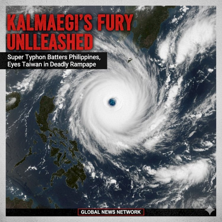
Kalmaegi's Fury Unleashed: Super Typhoon Batters Philippines, Eyes Taiwan in Deadly Rampage
 content-team
Manila Monsoon of Mayhem: Storm's 200 km/h Winds Flatten Homes, Trigger Evacuations in Millions
As the sun dipped below the horizon on November 5, 2025, the western Pacific became a cauldron of chaos, with Super Typhoon Kalmaegi barreling toward the Philippines like a freight train from hell. Clocked at a ferocious Category 5 equivalent, the monster storm—packing sustained winds of 215 km/h (134 mph) and gusts topping 260 km/h—slammed into Luzon’s eastern coast near Isabela province just after dawn, unleashing a torrent of destruction that has already claimed at least 27 lives and left over a million in desperate limbo. From flooded Manila streets to uprooted banana plantations in Bicol, Kalmaegi's wrath is rewriting disaster playbooks, forcing the archipelago's government into a frantic scramble amid warnings of "catastrophic" inland surges.
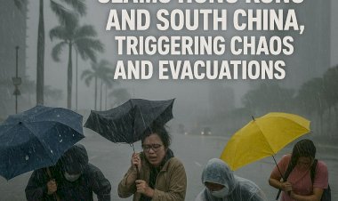
The storm's landfall, near the fishing village of Divilacan, was a spectacle of raw terror: walls of seawater 7 meters high (23 feet) crashed ashore, swallowing coastal hamlets whole and turning rice paddies into raging rivers. Eyewitnesses in Cauayan City described the scene as "the sky vomiting the ocean," with metal roofs peeling off like paper and power lines snapping like twigs. By midday, the Philippine Atmospheric, Geophysical and Astronomical Services Administration (PAGASA) hoisted its highest storm signal—Signal 5—over four provinces, evacuating 1.2 million souls in a chaotic exodus that clogged highways with mud-caked vehicles and families clutching sodden backpacks. "We've never seen anything like this since Haiyan," gasped one harried official in Tacloban, evoking memories of the 2013 super typhoon that killed 6,000.
Kalmaegi's rapid intensification— from a mere tropical depression to super typhoon in under 48 hours—has meteorologists scratching their heads and pointing fingers at a warming planet. "This is climate change on steroids," thundered Dr. Elena Vasquez, a lead researcher at Manila's state weather bureau, in a hastily convened presser. Satellite imagery revealed the storm's eye—a deceptively calm 25 km-wide void—swirling like a cosmic drain, fueled by record-hot ocean temps that supercharged its fury. As of 6 p.m. local time, the cyclone's center was churning northwest at 20 km/h, its outer rain bands already lashing Metro Manila with 300 mm (12 inches) of downpour in hours, paralyzing the capital's vaunted Skytrain and submerging Ninoy Aquino International Airport under a foot of brackish floodwater.
Evacuation Epic: Heroes and Heartbreak in the Typhoon's Shadow
Amid the howling gales, tales of resilience flickered like emergency beacons. In hard-hit Cagayan Valley, volunteer " typhoon tamers"—local farmers turned first responders—paddled bangkas through chest-deep floods to rescue stranded elders, while Philippine Red Cross teams air-dropped MREs via Black Hawk choppers dodging 100 km/h crosswinds. Heart-wrenching images flooded social media: a school turned shelter overflowing with 500 families, toddlers clutching soaked teddy bears; a viral clip of a fisherman lassoing a drifting schoolbus to shore. Yet, the toll mounts hourly—12 dead in landslides alone, with bridges sheared clean and 200,000 homes reduced to splintered matchsticks. President Ferdinand Marcos Jr., choppered into a command center in Quezon City, vowed "unprecedented aid," unlocking $500 million from contingency funds and mobilizing 50,000 troops for relief. "Kalmaegi tests our soul, but we will not break," he declared, his face etched with the gravitas of a leader staring down Armageddon.
The economic gut-punch is staggering: preliminary tallies peg damages at $2.3 billion, gutting the vital agriculture sector—80% of the nation's rice crop at risk—and snarling export ports from Subic Bay to Cebu. Global supply chains, already jittery from U.S. election jitters, brace for ripple effects: chocolate prices could spike 15% with Philippine cacao farms underwater, while typhoon-fueled diesel shortages loom over Asia's shipping lanes.
Taiwan on Red Alert: Kalmaegi's Encore Looms Over Taipei
As the Philippines reels, Kalmaegi's encore act targets Taiwan, where the Central Weather Administration has issued a rare "red typhoon warning" for the island's east coast. Expected landfall near Hualien by Friday morning, the storm could weaken to a still-potent Category 4 but promises 500 mm (20 inches) of rain in 24 hours—enough to trigger biblical mudslides in the Taroko Gorge. Taipei's streets, usually a neon blur of scooters, ground to a precautionary halt, with 300,000 evacuations ordered and TSMC's chip fabs battening down hatches against power flickers. "This is no drill—Kalmaegi's got more fight left," warned Taiwan's president, Lai Ching-te, in a nationwide address, as fighter jets were grounded and fishing fleets recalled to harbor.
A Wake-Up Call from the Warming Seas: When Will the Storms Stop?
Kalmaegi's rampage isn't isolated—it's the latest in a parade of Pacific behemoths, from Yagi's Vietnam devastation to this year's record 28 named storms. Scientists at the UN's climate panel murmur of a "new normal," where super typhoons strike twice as often, their fury amplified by seas 1°C hotter than pre-industrial levels. In Manila's sodden streets, survivors like 62-year-old fisherwoman Rosa Lim echo the dread: "The gods are angry, or maybe we've made them so."
As rescue choppers thrum overhead and aid convoys snake through debris-choked roads, the Philippines clings to fragile hope. Kalmaegi's eye may have passed, but its shadow lingers—a stark reminder that in our fragile world, nature's fury waits for no election, no apology. The cleanup begins at dawn, but the real storm? That's the one brewing in our collective conscience.